Uncovering Langsville Creek, Part 2 – The catchment

This is the second in a series of posts about Langsville Creek, which was Western Creek’s upstream neighbour on the Toowong/Milton Reach. You may want to check out Part 1 and Part 3 of the series.

The whole iceberg

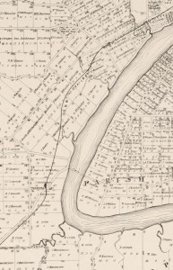
Langsville Creek as depicted on A.R. McKellar's map of Brisbane, published in 1895.

Langsville Creek as depicted on A.R. McKellar’s map of Brisbane, published in 1895.

If you look at the Milton Reach of the river on any of the old maps of Brisbane, such as the one drawn by A.R. McKellar in 1895 (shown to the right), you will notice a creek with several winding branches that meets the river at Patrick’s Lane. This was known as Langsville Creek. As we saw in Part 1 of Uncovering Langsville Creek, the creek as it was depicted on the old maps is now gone. A few drain openings are about the only physical reminders left of what must have once been a prominent part of the landscape.

But there must have been more to Langsville Creek than just the meandering branches shown on the early maps. Each of these branches must have had an origin somewhere further upstream. With one or two exceptions, the early maps show nothing of those upstream parts of the creek. Our understanding of Langsville Creek will remain very superficial, however, if we do not look further than what we can see on the maps. It would be like trying to understand an iceberg while ignoring everything under the water. If we want to uncover Langsville Creek and its legacy in today’s landscape, we need to look further upstream: we need to see the whole iceberg.

Continue reading

Correction – Langsville Creek catchment area

Just a quick note to mention that I have just updated the recent post about the catchments of the Crescent Reach to include a revised outline of the Langsville Creek catchment.

My first attempt at mapping that catchment omitted an area between (roughly) Ascog Terrace and Kensington Terrace, and including Toowong Village. I thought this might have been a separate catchment that discharged straight to the river, but closer inspection showed that it was actually a subcatchment of Langsville Creek. The give-away was the fact that one of the branches of Langsville Creek as depicted on the map from 1859 reached a good distance into this area.

So, Toowong Village is part of the Langsville Creek catchment after all (in fact I suspect it was built right on top of a watercourse), and the area of the catchment is about 3.3 km2 rather than the 2.7 km2 that I think I estimated the first time around.

I have also updated the kmz file that you can use in Google Earth to explore the catchments.

The catchments of the Crescent Reach

This post was updated on 24 May 2013 to include a revised outline of Langsville Creek catchment.
The Milton/Toowong Reach of the Brisbane River, depicted on a map from 1884.

The Milton/Toowong Reach of the Brisbane River, depicted on a map published in 1884

One of the first things I did when I created this website was to map out the catchment of Western Creek. While Western Creek has remained my focus, I have increasingly spent time thinking and writing about its neighbouring catchments as well, especially its three ‘sister’ catchments along what John Oxley called the Crescent Reach: Boundary Creek, Langsville Creek and Toowong Creek. These creeks are visible in several old maps, such as the one shown to the right, which dates from 1884.1

I figured that it was about time to put these other catchments onto a map. So, I fired up ArcMap, fed it some digital elevation data and eventually coaxed out of it the catchment boundaries. And of course, I then loaded them into Google Earth. The image below shows, from left to right, the catchments of Toowong Creek, Langsville Creek, Western Creek and Boundary Creek. (I haven’t mapped out the streams of the other catchments — that can wait for another day.)
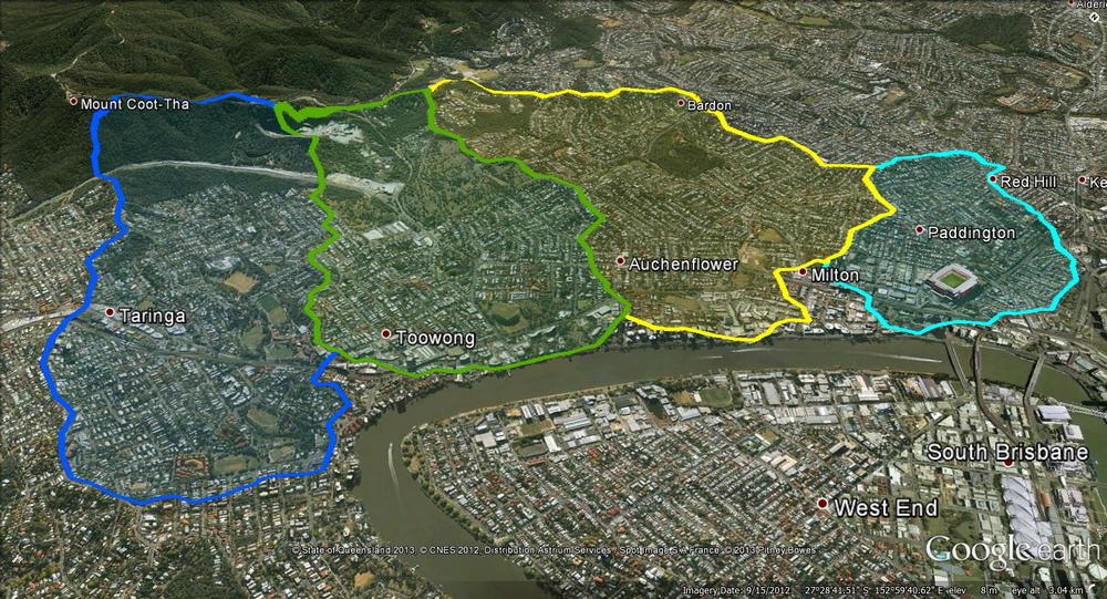
The catchments of the Crescent Reach. From left to right: Toowong Creek, Langsville Creek, Western Creek and Boundary Creek.

The catchments of the Crescent Reach. From left to right: Toowong Creek, Langsville Creek, Western Creek and Boundary Creek.

The precision of these boundaries is limited by the data used to create them, and you can tell by their jagged shapes that they are only approximations. Defining these boundaries can get particularly tricky as you get closer to the river, where the terrain is relatively flat.

But these boundaries don’t have to be perfect in order to be useful. The most interesting thing that they convey is the overall shape and size of the four catchments. At a glance, we can see that Boundary Creek is the smallest, while Toowong Creek and Western Creek are the largest. Using my GIS software, I calculated the catchment areas as follows:

Western Creek: 4.1 km2
Toowong Creek: 3.9 km2
Langsville Creek: 3.3 km2
Boundary Creek: 1.5 km2

I was surprised to discover that the Toowong Creek and Western Creek catchments are about the same size. I had always assumed that Toowong Creek was larger, and that this might be one reason why it (mostly) survived while Western Creek was (mostly) obliterated. But since their catchments are about the same size, their streams (at least in the lower reaches) should also have been comparable. Does this mean that we can use Toowong Creek as a reference point to tell us what Western Creek might have been like? Maybe, maybe not, as I suspect you would have to account for any notable differences in the geology, vegetation, topography and overall shape of the two catchments first. It is an interesting prospect, though.

Over the hill and far away

All four of these catchments share their uppermost boundaries with another catchment: that of Ithaca Creek. Ithaca Creek begins in the slopes of Mount Coot-tha and flows through Bardon, Ashgrove and Red Hill, where it meets its ‘parent’ stream, Enoggera Creek. The catchments of Ithaca Creek and Enoggera Creek are both shown in the image below, along with the four catchments of the Crescent Reach.
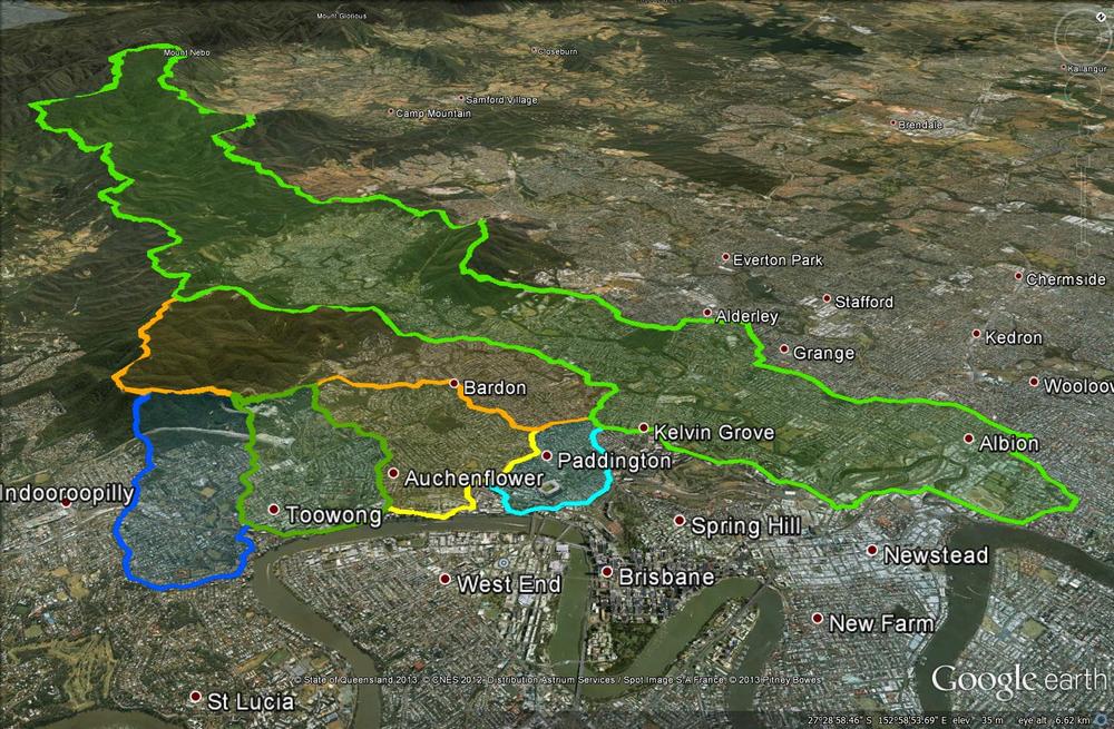
The four catchments of the Crescent Reach along with the larger catchments of Ithaca Creek and Enoggera Creek.

The four catchments of the Crescent Reach along with the larger catchments of Ithaca Creek and Enoggera Creek.

Ithaca Creek’s catchment covers an area of 11 km2 — almost as much as the four Crescent Reach catchments combined. But it too is dwarfed by the catchment of Enoggera Creek, which covers about 76 km2 (including Ithaca Creek, which is one of its tributaries) and extends all the way up through The Gap and into the D’Aguilar Range. No wonder Enoggera Creek was chosen to provide Brisbane’s first large-scale water supply.

And the rest of Brisbane? It could be mapped like this, too. In fact, I’d be surprised if the council hasn’t done it already, since these same catchments would delineate the networks of sewers and stormwater drains that the council maintains. And of course, where notable creeks still exist, their catchments will have been mapped to support monitoring and management initiatives such as Healthy Waterways. I hope that at some stage, this information will be made available for people to explore through Google Earth or similar platforms.

For now, you’ll have to make do with the six catchments I’ve discussed above. If you have installed Google Earth, then you can explore them yourself by opening (or downloading then opening) this file.

Notes:

  1. This map was produced by the Surveyor General’s Office in 1884. It is called ‘Moreton 20 chains to an inch, Sheet 1B’. It is held by the National Library of Australia, and is avaialble via Trove.

Uncovering Langsville Creek — Part 1

This is the first in a series of posts about Langsville Creek, which was Western Creek’s upstream neighbour on the Toowong/Milton Reach. I do not intend to research Langsville Creek fully at this stage, as I have too much still to learn about Western Creek. But I couldn’t resist tracing the path of this (mostly) lost creek and seeing what can be learned by looking at the some of the old maps and aerial photographs. Each post will look at a different part of Langsville Creek. This one focuses on the lowest reaches of the creek, near where it met the Brisbane River. You can also now read Part 2 and Part 3 of the series.

The meanders of Moorlands

Toowong Cemetery … Anzac Park … the Mount Coot-tha Botanical Gardens … Quinn Park … the McIlwraith Croquet Club … Toowong Memorial Park … Moorlands Park.

What do all of these places have in common? The answer is a creek. Not a creek you are likely to have seen or heard of, for there are few traces of it left today. But there once was a creek that flowed through all of these locations.

The creek uniting these locations was known to early Brisbanites as Langsville Creek, though I imagine that it also had names given to it by the Turrbal people long before Europeans arrived. I’ve not read up on how and when it came to be known as Langsville Creek, but given that just about everything else in this part of Brisbane is named after John Dunmore Lang, I’m going to take a punt and guess that this creek was as well.

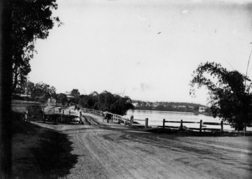
Langsville Bridge at Auchenflower, ca.1910. (State Library of Queensland, Negative no. 118279)

Langsville Bridge at Auchenflower, ca.1910. (State Library of Queensland, Negative no. 118279)

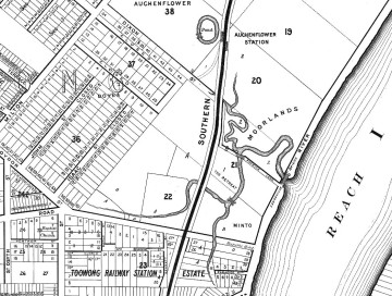
You can see Langsville Creek — or at least part of it — on the early maps of Brisbane. It’s depicted most clearly on McKellar’s 1895 map, the relevant portion of which is reproduced below. The creek itself is unnamed on this map, except by way of the bridge that crosses it where Patrick Lane meets the River Road (now Coronation Drive). The creek looks rather like an outgrowth of the river, as if the river has put out tentacles or feelers, each one meandering through the landscape much as the river winds its way to the bay. The land surrounding it appears to be mostly undeveloped, presumably because it was damp and flood-prone.

Continue reading

Fun with Google Earth

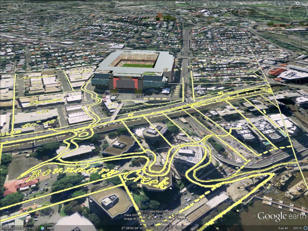
A few weeks back, I posted some images that I put together by combining old maps with recent aerial photographs. Since then, I’ve discovered how to import those same maps into Google Earth. This is really exciting, because it allows you to explore these maps in an interactive way. Instead of being stuck with an orthogonal ‘straight down’ view, you can move around and view things from any angle you choose. A gallery of examples is below. In these images are three different historical maps:

  • ‘Plan of the limits of the town of Brisbane’ (1843). You can see the original in the Queensland Historical Atlas.
  • ‘Plan of Portions 203 to 257 in the Environs of Brisbane, Parish of Enoggera, County of Stanley, New South Wales’ (1859). This is available at the Queensland State Archives (Item ID620656) and the State Library (Record 727379).
  • ‘Plan of Brisbane Water Works’ (1864). This map shows the pipeline route between Enoggera Reservoir and Brisbane City, and is available from the Brisbane City Council Archives.

Boundary Creek as depicted in 1864. In the foreground is the Coronation Drive Office Park, and behind it is Suncorp Stadium.

Boundary Creek as depicted on in 1864. In the foreground is the Coronation Drive Office Park, and behind it is Suncorp Stadium.


Continue reading